このデータベースは, 北海道大学附属図書館北方資料室等の所蔵資料を収録した8種の目録を、平成5年から平成20年にかけて「日本学術振興会:科学研究費補助金(研究成果公開促進費)」の交付を受け構築したものです。
ガラス乾板目録は,北海道大学附属図書館所蔵のガラス乾板を,平成25年度「公益財団法人日本科学協会笹川科学研究助成金」の交付を受けデジタル化したものです。
タイトル索引
[
ア
イ
ウ
エ
オ
カ
キ
ク
ケ
コ
サ
シ
ス
セ
ソ
タ
チ
ツ
テ
ト
ナ
ニ
ヌ
ネ
ノ
ハ
ヒ
フ
ヘ
ホ
マ
ミ
ム
メ
モ
ヤ
ユ
ヨ
ラ
リ
ル
レ
ロ
ワ
英字
数字
]
1796件ヒットしました。 全=全文あり / 画=画像あり / ![]() =高画質画像(IIIF)あり
=高画質画像(IIIF)あり
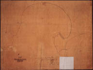
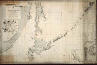
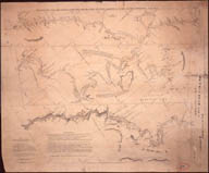
- Port of Hakodadi, Japan.(北海道関係地図・図類目録) 画

- Plan of Hakodate Harbour, showing Improvements referred to in Report, dated 14th Sept., 1888(北海道関係地図・図類目録)
- Plan of Street Distribution, (Hakodate).(北海道関係地図・図類目録)
- Fukuyama. Design showing proposed Harbour, 1889.(北海道関係地図・図類目録)
- Mori. Communication across Volcano Bay-proposed Harbour & Railway Pier.(北海道関係地図・図類目録)
- Sawara. Proposed Harbours & Railway Wharf.(北海道関係地図・図類目録)
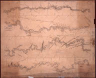
- Chart of Discoveries made in 1787, in the Seas of China and Tartary, by the Boussole & Astrolabe.(北海道関係地図・図類目録)
- Die Insel Krafto (Saghalien) und die Mundung des Manko (Amur) nach Originalkarten von Mocami Tokunai und Mamia Rinzo. / Philipp Franz von Siebold.(北海道関係地図・図類目録)
- Karte der Insel Sachalin, oder Karafto. / G. W. Schebunin(北海道関係地図・図類目録)
- Karte der Insel Sachalin, oder Karafto. / G. W. Schebunin(北海道関係地図・図類目録)
- Karte der Insel Sachalin, oder Karafto, zusammengestellt nach den Material-ien der Sibirischen Expedition der Kaiserlichen Geographischen Gesellschaft von G. W. Schebunin / G. W. Schebunin(北海道関係地図・図類目録) 画
- Karte der Insel Sachalin, oder Karafto, zusammengestellt nach den Materialien der Sibirischen Expedition der Kaiserlichen Geographischen Gesellschaft von G. W. Schebunin / G. W. Schebunin(北海道関係地図・図類目録) 画
- Plan of La Baie de Langle on the West Side of the Isle of Tchoka, 1787.(北海道関係地図・図類目録)
- Plan of La Baie D'Estaing on the Eastern Coast of Tchoka, 1787.(北海道関係地図・図類目録)
- Khanduza(& Pogibi)(北海道関係地図・図類目録) 画
- Aleksandrovsk-Sakhalinskiy(北海道関係地図・図類目録) 画
- Poluostrov Shmidta(北海道関係地図・図類目録) 画
- A Map of the Kurilski Islands, engraved from the Russian Map.(北海道関係地図・図類目録)
- Carte des Isles Kurilski.(北海道関係地図・図類目録)
- Charte der Kurilischen Inseln.(北海道関係地図・図類目録)
- Carte de I'Archipel des Kouriles.(北海道関係地図・図類目録)
- Carte de I'Archipel des Kouriles. (Golownin)(北海道関係地図・図類目録)
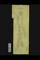
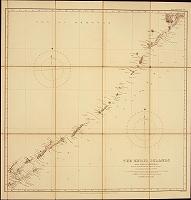
- The Kuril Islands from Nipon to Kamchatka. From Krusenstern, Siebold, Broughton and the RussianCharts.(北海道関係地図・図類目録) 画
- The Kuril Islands from Nipon to Kamchatka. From Krusenstern, Siebold, Broughton and the RussianCharts.(北海道関係地図・図類目録) 画
- The Kuril Islands from Yezo to Kamchatka from the latest British and Japanese surveys with additions by H. J. Snow, 1893.(北海道関係地図・図類目録) 画
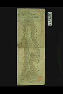
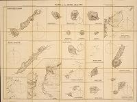
- Plans of the Kuril Islands, from sketches chiefly made by Mr. H. J. Snow,1893.(北海道関係地図・図類目録) 画
- Anonyme Portugiesische Seekarte(北海道関係地図・図類目録)
- Carte Nouvelle de la Grande Tartarie. / N. Witsen(北海道関係地図・図類目録)
- The Atlas of Siberia by Semyon U. Remezov. Facsimile edition, with anintroduction by Leo Bagrow.(北海道関係地図・図類目録)
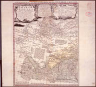
- Des Land Kamtzadalie sonst Jedso, mit der Lamskisch od. Pensinskischen See, 1725. / J. B. Homann(北海道関係地図・図類目録)
- Nova Descriptio Geographica Tattarica Magnae tam orientalis quam occidentalis in particularibus et generalibus Territoriis una cum Delineatione totius Imperii Russici imprimis Siberiae accurte ostensa. / Philipp Johann von Strahlenderg(北海道関係地図・図類目録)
- Imperii Russici Tabula Generalis. / Ioannis Kyrilow(北海道関係地図・図類目録)
- Carte Generale de la Tartarie Chinoise et des Rojaumes de Coree et de Iapan. / Jean-Baptiste B. D'Anville(北海道関係地図・図類目録) 画
- Carte Generale de la Tartarie Chinoise et des Rojaumes de Coree et de Iapan. / Jean-Baptiste B. D'Anville(北海道関係地図・図類目録) 画
- Carte Generale de la Tartarie Chinoise. / D'Anville(北海道関係地図・図類目録)
- Carte des Isles du Japon et des Costes de la Chine. / Bellin(北海道関係地図・図類目録)
- Chart of the voyage of Bering and Chirikov in the “St. Peter""and the “St. Paul"" from Kamtchatka to the Alaskan Coast and Return, 1741. / E. P. Bertholf(北海道関係地図・図類目録)
- A Map of the Discoveries made by the Russians on the North West Coast of America. / Royal Academy of Sciences at Petersburg(北海道関係地図・図類目録)
- Ostium Fluvii Amur cum Parte Australiori Terrae Kamtschatkae variisque in Oceano sitis insulis inter quas pars eminet Japoniae.(北海道関係地図・図類目録)
- Carte des Nouvelles Decouvertes au Nord de la Mer du Sud, tant a l'Est de la Siberie et du Kamtschatka. / N. De L'Isle(北海道関係地図・図類目録)
- Troisieme partie de la Carte d'Asie / D'Anville(北海道関係地図・図類目録)
- Carte des Isles du Japon, Terre de Jesso et Pays Voisins. / Bellin(北海道関係地図・図類目録)
- Nouvelle Carte des Decouvertes faites par des Vaisseaux Russiens aux cotes inconnues de l'Amerique Septentrionale avec les Pais adiacents, 1758.(北海道関係地図・図類目録)
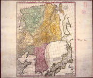
- A Map of Kamtschatka, engraved from the Russian Map(北海道関係地図・図類目録)
- Carte de Kamtschatka.(北海道関係地図・図類目録)
- Karte von der Lage von Kamtschatka.(北海道関係地図・図類目録)
- Carte du Kamtchatka, dresse sur les Observations de Mr. Kracheninnikowraportees dans son Voyage au Kamtschatka par Mr. L'Abbe Chappe d'Auteroche.(北海道関係地図・図類目録)
- Karte von der Lage von Kamtschatka.(北海道関係地図・図類目録)
- Cartes Reduite de l' Ocean Septentrional compris entre l'Asie et Amerique. / Bellin(北海道関係地図・図類目録)
- Krenitzin's and Levasheff's Voyage to the Fox Islands in 1768 and 1769.(北海道関係地図・図類目録)
- Krenitzin's and Levasheff's Voyage to the Fox Islands in 1768 and 1769.(北海道関係地図・図類目録)
- General Map of the Russian Empire.(北海道関係地図・図類目録)
- Carte Generale des Decouvertes faites en 1787 dans les Mers de Chine et de Tartarie. / J. F. La Perouse(北海道関係地図・図類目録)
- Plan of Baie de Ternai, 1787.(北海道関係地図・図類目録)
- Route of M. de Lesseps, Consul of France, in the Peninsula of Kamtschatka.(北海道関係地図・図類目録)
- Chart of the Strait between Asia & America with the Coast of the Tschutski, Iaid down from Astronomical Observations, made in the Icy Sea during the years 1786 &c. to 1794. / A. Arrowsmith.(北海道関係地図・図類目録)
- A Chart of the N. E. Coast of Asia, and Japanese Isles. / W. R. Broughton(北海道関係地図・図類目録)
- A Chart of the N. E. Coast of Asia, and Japanese Isles. / W. R. Broughton(北海道関係地図・図類目録)
- Chart of the Russian & English Discoveries in the North Pacific Ocean.(北海道関係地図・図類目録)
- Map of the Eastern part of Siberia, and the Peninsula of Kamtchatka, compiled from the latest Authorities.(北海道関係地図・図類目録)
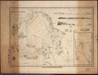
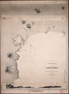
- Awatska Bay, by Capt. F. W. Beechey in H. M. S. Blossom, 1827.(北海道関係地図・図類目録) 画
- Outer Bay of Awatska by Capt. F. W. Beechey, 1827.(北海道関係地図・図類目録) 画
- General-Karte einer……durch Ferdinad von Wrangel in dem nordoestlichen Theile Sibiriens u. auf dem Eismeere unternommenen Reise.(北海道関係地図・図類目録)
- Carte Generale de La Mer de Behring, 1828.(北海道関係地図・図類目録)
- General Map of a Part of Russian Possessions in America. / L. A. Zagoskin(北海道関係地図・図類目録)
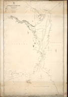
- Map of the Regions of the Amur, 1861. / E. G. Ravenstein.(北海道関係地図・図類目録)
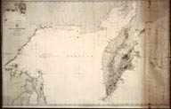
- Sea of Okhotsk from Russians Charts of 1849~51.(北海道関係地図・図類目録) 画
- Strait of Tartary and the Entrance of the Amur River from Russian Survets.(北海道関係地図・図類目録) 画
- Karte des Amgun und Bureya Gebiets, 1865. / G. W. Schebunin(北海道関係地図・図類目録)
- Ethnographische Karte des Asiatischen Russlands. / Wenjukow(北海道関係地図・図類目録)
- Map of Alaska and Adjoining Regions. / Ivan Petroff(北海道関係地図・図類目録)
- Map of Alaska and Adjoining Regions. showing the Distribution of Native Tribes. / Ivan Petroff(北海道関係地図・図類目録)
- Karte von Kamtschatka, vervollstandigt nach den Tagebuchern von K. von Ditmar.(北海道関係地図・図類目録)
- Ethnologic Map of Siberia.(北海道関係地図・図類目録)
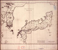
- Iaponia Regnum. / Martino Martini(北海道関係地図・図類目録) 画
- L'Empire du Japon divise en sept principales parties, savoir, Ochio Quanto, Jetsegen, Jetsen, Jamaisoit, Xicoco et Ximo, et subdivise en soixante et six Royaumes. / Robert, S.(北海道関係地図・図類目録)
- A Chart of the N. E. Coast of Asia, and Japanese Isles……under the Command of Wm. Robt. Broughton Esqr.(北海道関係地図・図類目録)
- Carte du Japon et de la Coree.(北海道関係地図・図類目録)
- Japan:Nippon, Kiusiu and Sikok and a part of the coast of Korea, according to Krusenstern's chart of 1827.(北海道関係地図・図類目録)
- Karte vom japanischen Reiche, nach Originalkarten und astronomischen Beobachtungen der Japaner;die Inseln Kiusiu, Sikok und Nippon. / Philipp Franz von Siebold(北海道関係地図・図類目録)
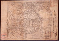
- Orographical and Hydrographical Map of Japan (Dai-Nippon). / J. Rittau(北海道関係地図・図類目録)
- Atlas zur Geschichte der Kartographie der Japanischen Inseln. / Paul Teleki.(北海道関係地図・図類目録)
- Atlas zur Geschichte der Kartographie der Japanischen Inseln. / Paul Teleki.(北海道関係地図・図類目録)
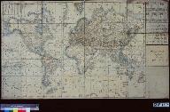
- A Map of the World in Japanese.(北海道関係地図・図類目録) 画
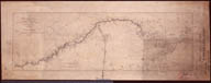
- The Yang-Tse Kiang, from Han-Kow to Pingshan;from the survey of Captain Blakiston, R. A. in 1861.(北海道関係地図・図類目録) 画
- The Yang-Tse Kiang, from Han-Kow to Pingshan;from the survey of Captain Blakiston, R. A. in 1861.(北海道関係地図・図類目録) 画
- The Yang-Tse Kiang, from Han-Kow to Pingshan;from the survey of Captain Blakiston, R. A. in 1861.(北海道関係地図・図類目録) 画
- The Yang-Tse Kiang, from Han-Kow to Pingshan;from the survey of Captain Blakiston, R. A. in 1861.(北海道関係地図・図類目録) 画
- Karte von Asien. / F. Handtke(北海道関係地図・図類目録)
- Map of New South Wales, shewing territorial divisions for purpose of the proposed “Crown Lands Act of 1884. ""(北海道関係地図・図類目録)
- Australien und die Sudsee. / F. Handtke(北海道関係地図・図類目録)
- Offcial Map of San Francisco. / W. M. Eddy(北海道関係地図・図類目録)
- Karte von Sud-Amerika. / F. Handtke(北海道関係地図・図類目録)
- Karte von Europa. / F. Handtke(北海道関係地図・図類目録)
- Afrika. / A. Herrich(北海道関係地図・図類目録)
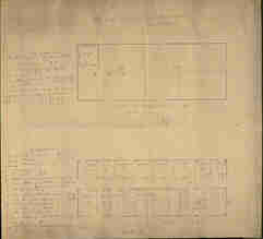
- Design for Shutter for Mathematical Recitation Room. / Peabody, Cecil Hobart(北海道関係地図・図類目録)
- Design for Military Hall, Sapporo Agricultural College. / William Wheeler(北海道関係地図・図類目録)
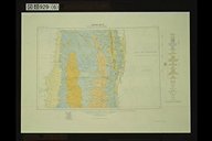
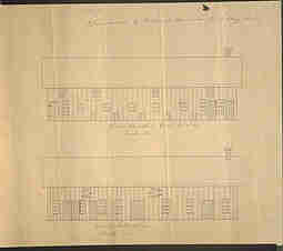
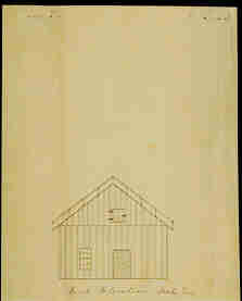
- Plan of Addition to College Barn 1 / William Penn Brooks(北海道関係地図・図類目録) 画
- Plan of Addition to College Barn 2 / William Penn Brooks(北海道関係地図・図類目録) 画
- Plan of Addition to College Barn 3 / William Penn Brooks(北海道関係地図・図類目録) 画